Hawaii Map and Hawaii Satellite Images
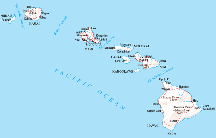
Discover the stunning islands of Hawaii with our interactive map. Explore the natural beauty and tourist attractions of this tropical paradise. Plan your next vacation or simply satisfy your wanderlust with WorldMap1's Hawaii map.For all Hawaii Cities Map
Hawaii Map & Hawaii Satellite Images
map of hawaii

Discovering the Magic of Honolulu Top 10 Must-Visit Spots
Please subscribe on "World Guide" channnel on Youtube at youtube.com/c/WorldGuide
Hawaii Map & Hawaii Satellite Images
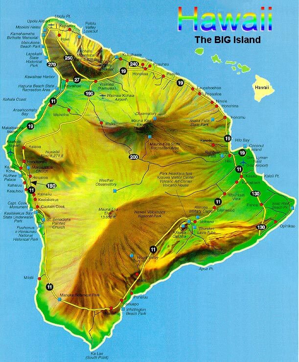
hawaii big island map

Hawaii Maps
- Map of Hawaii
- Hawaii Islands Map
- Hawaii Map
- Hawaii Big Island Map
- Hawaii Cities Map
- Hawaii Islands Map US
- Hawaii Islands Map Pasific Ocean
- Hawaii Map United States of America
- Hawaii Map Island
- Hawaii Maps Islands
- Hawaii Road Map
- Hawaii Terrain Map
- Map of Hawaii USA
- Map of Hawaii United States
- Map of Hawaii Big Island
- Principal Islands of Hawaii Map
- The Islands of Hawaii Map
- Volcano Cottage Map of Hawaii
Brief information about Hawaii, US
Hawaii is a state located in the Pacific Ocean and is part of the United States. It is the only U.S. state that is completely made up of islands, consisting of eight main islands and numerous smaller ones. The capital city is Honolulu, which is located on the island of Oahu. Hawaii has a unique and diverse culture, influenced by its Polynesian roots, as well as the various waves of migration and colonization that have occurred over the years.A Collection of Hawaii Maps and Hawaii Satellite Images
MAP OF HAWAII

HAWAII ISLANDS MAP

HAWAII MAP

HAWAII BIG ISLAND MAP

HAWAII CITIES MAP

HAWAII ISLANDS MAP

HAWAII ISLANDS MAP PASIFIC OCEAN

HAWAII MAP

HAWAII MAP ISLAND

HAWAII MAPS ISLANDS

HAWAII ROAD MAP

HAWAII TERRAIN MAP

MAP OF HAWAII

MAP OF HAWAII

MAP OF HAWAII BIG ISLAND

PRINCIPAL ISLANDS OF HAWAII MAP

THE ISLANDS OF HAWAII MAP

VOLCANO COTTAGE MAP OF HAWAII

A collection of Hawaii Maps
Largest Cities Map of Hawaii and Population
- Honolulu Map - 387,170 - (21.307,-157.858)
- Pearl City Map - 47,698 - (21.397,-157.973)
- Hilo Map - 43,263 - (19.73,-155.09)
- Kailua Map - 38,635 - (21.402,-157.739)
- Waipahu Map - 38,216 - (21.387,-158.009)
- Kaneohe Map - 34,597 - (21.418,-157.804)
- Mililani Town Map - 27,629 - (21.45,-158.001)
- Kahului Map - 26,337 - (20.895,-156.47)
- Ewa Gentry Map - 22,690 - (21.344,-158.031)
- Mililani Mauka Map - 21,039 - (21.48231160000,-157.94640130000)
- Kihei Map - 20,881 - (20.785,-156.466)
- Makakilo Map - 18,248 - (21.346944, -158.085833)
- Wahiawa Map - 17,821 - (21.502778, -158.023611)
- Schofield Barracks Map - 16,370 - (21.489811, -158.050604)
- Wailuku Map - 15,313 - (20.891111, -156.504722)
- Head of Performance Marketing
- Head of SEO
- Linkedin Profile: linkedin.com/in/arifcagrici
Largest Cities Map of Hawaii and Population
Honolulu Map - 387,170 Pearl City Map - 47,698 Hilo Map - 43,263 Kailua Map - 38,635 Waipahu Map - 38,216 Kaneohe Map - 34,597 Mililani Town Map - 27,629 Kahului Map - 26,337 Ewa Gentry Map - 22,690 Mililani Mauka Map - 21,039 Kihei Map - 20,881 Makakilo Map - 18,248 Wahiawa Map - 17,821 Schofield Barracks Map - 16,370 Wailuku Map - 15,313
Addresse: Hakarinne 2 Espoo, Uusimaa - Finland 02210
Web: istanbul-city-guide.com
Email: [email protected]
Phone: +358 44 934 9129
Web: istanbul-city-guide.com
Email: [email protected]
Phone: +358 44 934 9129
Copyright istanbul-city-guide.com - 2004 - 2025. All rights reserved. Privacy Policy | Disclaimer


