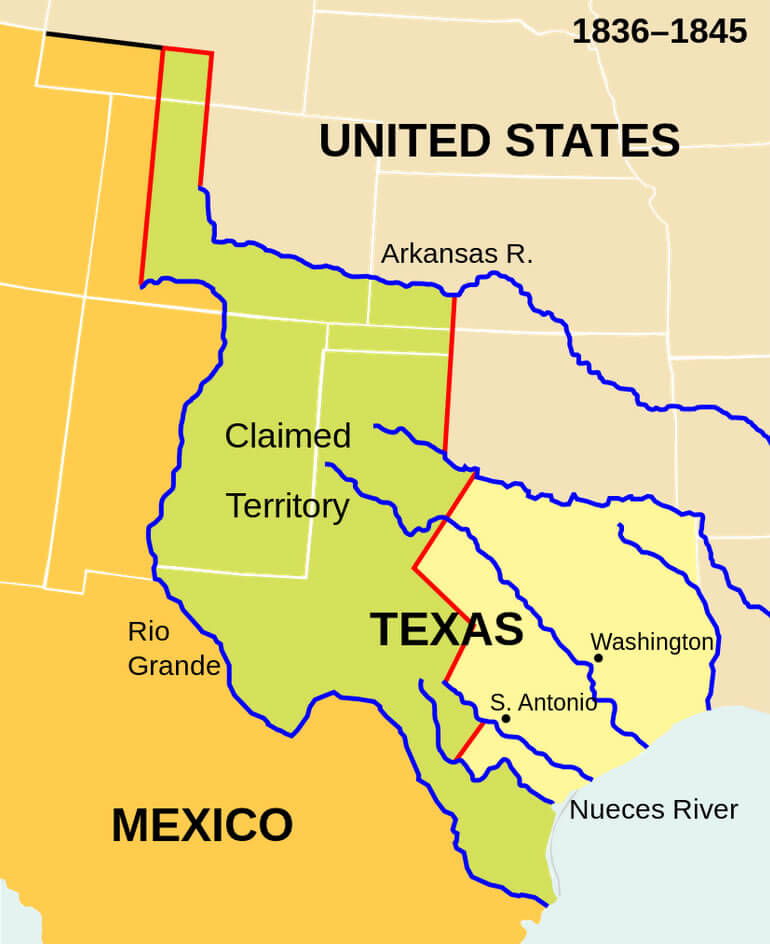
Republic of Texas Map USA 1836 1845
Republic of Texas. The present-day outlines of the U.S. states superimposed on the boundaries of 1836–1845.
Where is Texas in the US and Cities Map of Texas
Please subscribe on "World Guide" channnel on Youtube at youtube.com/c/WorldGuide
Largest Cities Map of Texas and Population
- Houston Map - 2.099.451 - (29.760193, -95.369390)
- San Antonio Map - 1.327.407 - (29.424 / -98.494)
- Dallas Map - 1.197.816 - (32.783 / -96.807)
- Austin Map - 790.390 - (30.267 / -97.743)
- Fort Worth Map - 741.206 - (32.725 / -97.321)
- El Paso Map - 649.121 - (31.759 / -106.487)
- Arlington Map - 365.438 - (32.736 / -97.108)
- Corpus Christi Map - 305.215 - (27.801 / -97.396)
- Plano Map - 259.841 - (33.02 / -96.699)
- Laredo Map - 236.091 - (27.506 / -99.508)
- Lubbock Map - 229.573 - (33.577863, -101.855166)
- Garland Map - 226.876 - (32.912624, -96.638883)
- Irving Map - 216.290 - (32.814018, -96.948894)
- Amarillo Map - 190.695 - (35.221997, -101.831297)
- Grand Prairie Map - 175.396 - (32.745964, -96.997785)
- Brownsville Map - 175.023 - (25.901747, -97.497484)
- Pasadena Map - 149.043 - (29.691063, -95.209101)
- Mesquite Map - 139.824 - (32.766796, -96.599159)
- McKinney Map - 131.117 - (33.197246, -96.639782)
- McAllen Map - 129.877 - (26.203407, -98.230012)
- Killeen Map - 127.921 - (31.117119, -97.727796)
- Waco Map - 124.805 - (31.549333, -97.146670)
- Carrollton Map - 119.097 - (32.975642, -96.889964)
- Beaumont Map - 118.296 - (30.080174, -94.126556)
- Abilene Map - 117.063 - (32.448736, -99.733144)
- Frisco Map - 116.989 - (33.150674, -96.823612)
- Denton Map - 113.383 - (33.214841, -97.133068)
- Midland Map - 111.147 - (31.997346, -102.077915)
- Wichita Falls Map - 104.553 - (33.913708, -98.493387)
- Odessa Map - 99.940 - (31.845682, -102.367643)
- Round Rock Map - 99.887 - (30.508255, -97.678896)
- Richardson Map - 99.223 - (32.948179, -96.729720)
- Tyler Map - 96.900 - (32.351260, -95.301062)
- Lewisville Map - 95.290 - (33.046233, -96.994174)
- College Station Map - 93.857 - (30.627977, -96.334407)
- The Woodlands Map - 93.847 - (30.165821, -95.461263)
- San Angelo Map - 93.200 - (31.463772, -100.437038)
- Pearland Map - 91.252 - (29.563567, -95.286047)
- Allen Map - 84.246 - (33.103174, -96.670550)
- League City Map - 83.560 - (29.507454, -95.094930)
- Longview Map - 80.455 - (32.500704, -94.740489)
- Sugar Land Map - 78.817 - (29.619679, -95.634946)
- Edinburg Map - 77.100 - (26.301737, -98.163343)
- Mission Map - 77.058 - (26.215907, -98.325293)
- Bryan Map - 76.201 - (30.674364, -96.369963)
- Baytown Map - 71.802 - (29.735505, -94.977427)
- Pharr Map - 70.400 - (26.194796, -98.183622)
- Missouri City Map - 67.358 - (29.618567, -95.537722)
- Temple Map - 66.102 - (31.098234, -97.342782)
- Atascocita Map - 65.844 - (29.998831, -95.176598)
- Harlingen Map - 64.849 - (26.190631, -97.696103)
- Flower Mound Map - 64.669 - (33.014567, -97.096955)
- North Richland Hills Map - 63.343 - (32.834295, -97.228903)
- Victoria Map - 62.592 - (28.805267, -97.003598)
- New Braunfels Map - 57.740 - (29.703002, -98.124453)
- Mansfield Map - 56.368 - (32.563192, -97.141677)
- Conroe Map - 56.207 - (30.311877, -95.456051)
- Rowlett Map - 56.199 - (32.902902, -96.563880)
- Spring Map - 54.298 - (30.079940, -95.417160)
- Port Arthur Map - 53.818 - (29.884950, -93.939947)
- Euless Map - 51.277 - (32.837073, -97.081954)
- Head of Performance Marketing
- Head of SEO
- Linkedin Profile: linkedin.com/in/arifcagrici
- Head of Performance Marketing
- Head of SEO
- Linkedin Profile: linkedin.com/in/arifcagrici
Google Map, Street Views, Maps Directions, Satellite Images
Istanbul-City-Guide.com offers a collection of map, google map, atlas, political, physical, satellite view, country infos, cities map and more map of .
Addresse: Hakarinne 2 Espoo, Uusimaa - Finland 02210
Web: istanbul-city-guide.com
Email: [email protected]
Phone: +358 44 934 9129
Web: istanbul-city-guide.com
Email: [email protected]
Phone: +358 44 934 9129
Copyright istanbul-city-guide.com - 2004 - 2025. All rights reserved. Privacy Policy | Disclaimer

