
State Map of Michigan, USA
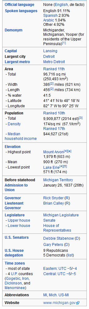
Michigan is a state in the Great Lakes region of the Midwestern United States. The name Michigan is the French form of meaning "large water" or "large lake". Michigan is the ninth most populous of the 50 United States, with the 11th most extensive total area (the largest state by total area east of the Mississippi River). Michigan's capital is Lansing, and the largest city is Detroit.

Largest Cities Map of Michigan and Population
- Detroit Map - 713.777 - (42.331427000000, -83.045753800000)
- Grand Rapids Map - 188.040 - (42.963,-85.668)
- Warren Map - 134.056 - (42.478,-83.028)
- Sterling Heights Map - 129.699 - (42.58,-83.03)
- Lansing Map - 114.297 - (42.733,-84.556)
- Ann Arbor Map - 113.934 - (42.278,-83.741)
- Flint Map - 102.434 - (43.013,-83.687)
- Dearborn Map - 98.153 - (42.322,-83.176)
- Livonia Map - 96.942 - (42.368,-83.353)
- Clinton Township Map - 96.796 - (42.587,-82.92)
- Canton Township Map - 90.173 - (42.308644, -83.482116)
- Westland Map - 84.094 - (42.324204, -83.400211)
- Troy Map - 80.980 - (42.605589, -83.149930)
- Farmington Hills Map - 79.740 - (42.482822, -83.418382)
- Kalamazoo Map - 74.262 - (42.291707, -85.587229)
- Shelby Township Map - 73.804 - (42.670782, -83.032993)
- Wyoming Map - 72.125 - (42.913360, -85.705309)
- Southfield Map - 71.739 - (42.473369, -83.221873)
- Waterford Township Map - 71.707 - (42.690744, -83.406613)
- Rochester Hills Map - 70.995 - (42.658366, -83.149932)
- Head of Performance Marketing
- Head of SEO
- Linkedin Profile: linkedin.com/in/arifcagrici
- Head of Performance Marketing
- Head of SEO
- Linkedin Profile: linkedin.com/in/arifcagrici
Google Map, Street Views, Maps Directions, Satellite Images
Istanbul-City-Guide.com offers a collection of map, google map, atlas, political, physical, satellite view, country infos, cities map and more map of .
Addresse: Hakarinne 2 Espoo, Uusimaa - Finland 02210
Web: istanbul-city-guide.com
Email: [email protected]
Phone: +358 44 934 9129
Web: istanbul-city-guide.com
Email: [email protected]
Phone: +358 44 934 9129
Copyright istanbul-city-guide.com - 2004 - 2025. All rights reserved. Privacy Policy | Disclaimer